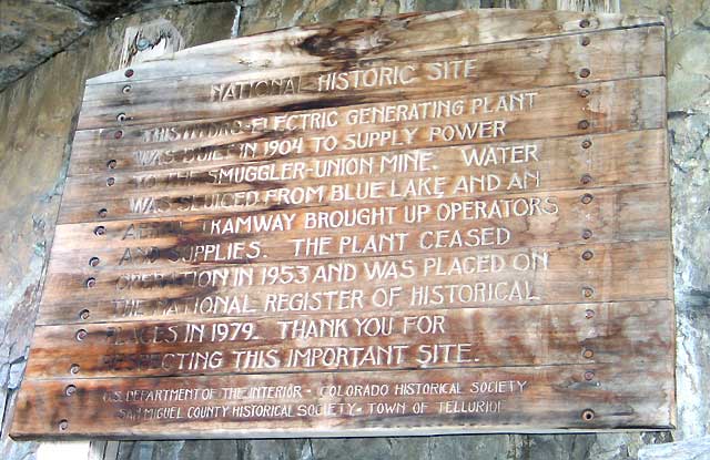
NATIONAL HISTORIC SITE - THIS HYDRO-ELECTRIC GENERATING PLANT WAS BUILT IN 1904 TO SUPPLY POWER TO THE SMUGGLER-UNION MINE. WATER WAS SLUICED FROM BLUE LAKE AND AN AERIAL TRAMWAY BROUGHT UP OPERATORS AND SUPPLIES. THE PLANT CEASED OPERATION IN 1953 AND WAS PLACED ON THE NATIONAL REGISTER OF HISTORICAL PLACES IN 1979. (Scroll down for more...)
|
Click the menu items in the frame at the left for photos or our journey to the top. Ingram Peak sits to the east of Telluride. Our first sighting of this remarkable view was back in 1968 while driving our Jeep up the trail to Savage Basin. Other times were in 1971 and 1974 when we went on up to Imogene Pass. Each trip, I would look over at the power station and wonder what it was like over there. The road, however, looked foreboding with many switchbacks and like it could slide down the mountainside at a moments notice. In recent years, vegetation has grown to hold the erosion and slides, but winter avalanches are still a problem. You can see the power station under the red arrow and a parked Jeep at the left under another red arrow. The Idarado Mill is seen at the lower left. To the upper far right, lies Blue Lake, the principle water source. This year (2004) was the exception. The time was right, the weather was right and the pull of magnetism simply made me go up the road. Black Bear trail joins into this road near the power station gate, but it is one-way down only. You can find many other sites detailing Black Bear trail on the web and it would appear that it is the most talked about, treacherous trail in Colorado. Suffice it to say that I was pleased to make it up to the Power Station. The view back down to the town of Telluride appears to be a quiet natural setting for a small town, but since 1968 it has grown into a monster of a tourist trap with all the luxurious trimmings for the winter ski crowd. I'll stick to the earth's natural wonders outside of the town, thank you. (Silverton and Creede are still unspoiled, for the time being.) Bridal Veil Falls tumbles over 400 feet, the tallest in Colorado. From the switchback right below it, the station looks like a castle in the sky! As we round the last switchback, a full view of the site is seen and we are almost there. As we look at the way back down, we wonder at the view and why we never did this before. The rest of the way to the power plant must be traveled on foot as the gate is closed. We are advised to keep on the trail because it runs through the privately owned power station property. At least it says that we may pass through, so it's time to hike. Looking back at my Jeep, you can see that it's slim parking there. I had just enough room to turn around. Another look to the left shows where Black Bear Trail comes down to join the roadway down to the Idarado Mill, Liberty Bell mine and towns of Pandora and Telluride. A short hike up the trail and around a bend and the full view behind the station is breathtaking. Notice the Idarado Mining Mill in the background - other photos will reference this location. The switchgear and transformers with a sign cautioning that 12,470 volts are to be respected. (The generator output is 2,300 volts, which is stepped up to line level by the transformer.) The penstock has a main water valve and looking up, the penstock comes from a source above at Blue Lake. I assure you that this is up at a 45 degree angle! The generator room is in the basement level of the privately owned building and is not available for public view. Time to leave. The narrow road back to the gate and the Jeep is just wide enough to accommodate a Jeep, while hugging the rocks on one side and the cliff on the other. The old tram line crosses overhead. A great day on the trail! We returned at a later date for a tour of the generator room by owner Eric Jacobson. The plant happened to be down for repair at the time, so we got a peek inside the port hole for a look at the wheel cups inside the Pelton Wheel. For a wide range look at the mountains: CLICK HERE The Idarado Mill is highlighted in the center as well as the falls by Black Bear Trail. Imogene Pass is at the upper left corner at 13,114 feet. Here's a satellite view of the power house: CLICK HERE Area History:Lore, Legend and Fact Western Colorado Power Company Collection The Mineralogy, Geology, and Mining History of the Telluride District Jeep Trips: Black Bear Road Ophir Pass Cinnamon Pass Engineer Pass Imogene Pass Look for our other power house photos of Ouray and Delta and Ames. |